The Future of Maritime Spatial Planning Data
Designing a Marine Spatial Data Infrastructure (MDSI) Prototype for Maritime Spatial Planning Data in the Baltic Sea
The prototype will be the first step towards a more efficient way to access MSP data from the original databases via compliant online standard services and formats. HELCOM will develop further the prototype after the project has ended in early 2019.
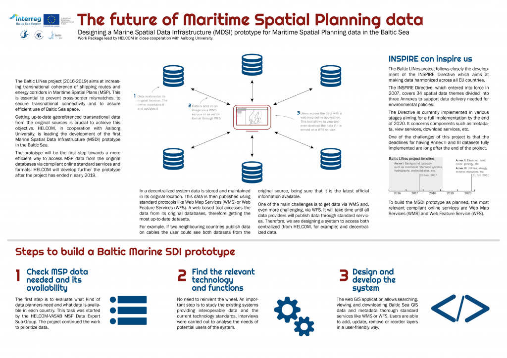
In a decentralized system data is stored and maintained in its original location. This data is then published using standard protocols like Web Map Services (WMS) or Web Feature Services (WFS). A web-based tool accesses the data from its original databases, therefore getting the most up-to-date datasets.
For example, if two neighbouring countries publish data on cables the user could see both datasets from the original source, being sure that it is the latest official information available. One of the main challenges is to get data via WMS and, even more challenging, via WFS. It will take time until all data providers will publish data through standard services. Therefore, we are designing a system to access both centralized (from HELCOM, for example) and decentralized data.
INSPIRE can inspire us
The Baltic LINes project follows closely the development of the INSPIRE Directive which aims at making data harmonized across all EU countries. The INSPIRE Directive, which entered into force in 2007, covers 34 spatial data themes divided into three Annexes to support data delivery needed for environmental policies. The Directive is currently implemented in various stages aiming for a full implementation by the end of 2020. It concerns components such as metadata, view services, download services, etc.
One of the challenges of this project is that the deadlines for having Annex II and III datasets fully implemented are long after the end of the project. To build the MSDI prototype as planned, the most relevant compliant online services are Web Map Services (WMS) and Web Feature Service (WFS).
Steps to build a Baltic Marine SDI prototype
1. Check MSP data needed and its availability
The first step is to evaluate what kind of data planners need and what data is available in each country. This task was started by the HELCOM-VASAB MSP Data Expert Sub-Group. The project continued the work to prioritize data.
2. Find the relevant technology and functions
No need to reinvent the wheel. An important step is to study the existing systems providing interoperable data and the current technology standards. Interviews were carried out to analyse the needs of potential users of the system.
3. Design and develop the system
The web GIS application allows searching, viewing and downloading Baltic Sea GIS data and metadata through standard services like WMS or WFS. Users are able to add, update, remove or reorder layers in a user-friendly way.
Download the infographic of the future of maritime spatial planning data HERE.