BSR MSP data infrastructure
BSR MSP data infrastructure for shipping routes and energy corridors
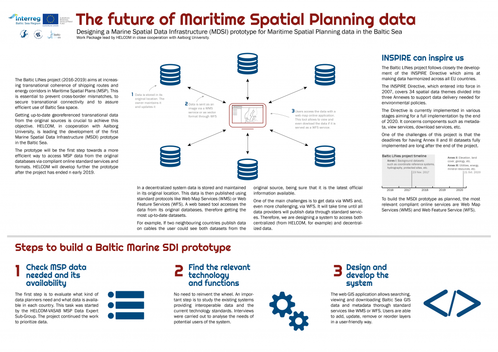
Successful implementation of MSP depends on good quality data and even more so on aggregated, spatially interpretable information. This has been widely acknowledged at policy and project level and is subject of the numerous EU Directives (i.e. MSP, INSPIRE, MFSD). In reality, access to relevant, spatial data and information has so far been a constant challenge in MSP. At seabasin level, this problem is aggravated as data and information is not always freely accessible to foreign planners and/or not neatly comparable as different data sets are used.
Aim of the project activity
The HELCOM-VASAB principles on MSP (2010) acknowledge that “close collaboration is needed between relevant GIS systems and geostatistical databases to facilitate the transboundary process of data exchange, which should lead to a harmonised pan-Baltic data and information base for planning. Baltic LINes aims to provide the starting point for turning this vision into a reality by developing a system, which offers an interactive webmap user interface for discovering, accessing, analysing and displaying harmonised crossborder data and information based on a Baltic Sea Spatial Data Infrastructure (SDI) prototype.
It will also serve as the information basis for the MSP Challenge. The simultaneous access to transboundary information on human activities and environment shall support MSP authorities to create sustainable plans allowing for Blue Growth and ecosystem recovery. The work package will be closely interlinked with the work of the HELCOM-VASAB subgroup on MSP Data.
The main responsible project partner for BSR MSP data infrastructure is HELCOM.
Activity outputs
BASEMAPS – Baltic Sea up-to-date data for MSP – https://basemaps.helcom.fi/ allows users to view and download data/metadata published by national data providers through OGC open geospatial standards— WMS and WFS. It is also possible to access downloadable services and ArcGIS REST Map layers. It is aimed for planners, data providers and authorities dealing with maritime spatial planning in the Baltic Sea.
How to use BASEMAPS? Download the detailed instructions ans start using BASEMAPS. Download here.
Short information about BASEMAPS – download a flyer here.
Download an infographic to learn more about the development of the Baltic Marine SDI prototype – here.